Autumn is officially here, and with it heavy rain and thunderstorms throughout the day to reinforce the message that summer is officially over.
A weather warning for rain is in force lasting all of Sunday for Wales and central south-west England, and another on Monday, stretching to cover areas further east and further north.
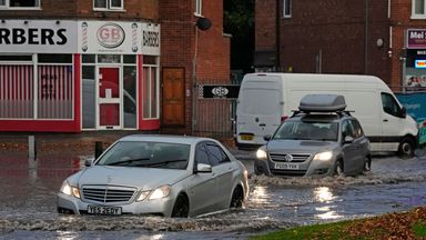
Authorities have warned of potential travel disruption, flooding and power cuts.
Officials also say there is a small chance homes and businesses could be flooded rapidly, with fast-flowing or deep floodwater causing "danger to life".
They also warned there was a small chance some communities could be cut off by flooded roads, with possible power cuts and cancellations to train and bus services.

The wet weather comes as the autumn equinox kicks off, marking the start of the astronomical autumn.
For simplicity, meteorologists often say this annual season change takes place on 1 September each year.
Sky News weather presenter Jo Wheeler said: "Meteorological summer began on 1 September but today, the autumn equinox, represents the start of the autumn in most people's understanding. And summer is certainly not making a quiet exit.
"High pressure is still hanging on by its fingernails in the north, maintaining an easterly flow on to North Sea coasts, as it has done through much of the week.
"But low pressure (the remnants of Storm Boris, which brought extensive flooding to central and eastern Europe earlier in the week) has moved into England and Wales. The rain is now rotating around the low centre in the south-west.
"Alongside the rain, there'll be some heavy, slow-moving showers in the south. All ways round, there's likely to be some significant rainfall over central, southern and western England with a threat of disruption to public transport, challenging driving conditions and the risk of flash floods.
"Running up against the stubborn high pressure in the north, there's nowhere for this low-pressure system to go, adding to the rainfall totals.
"There'll be little change into tomorrow with an amber warning already issued for central England, Lincolnshire and Yorkshire. Again, there'll be some heavy, slow-moving rain and some thundery showers further south.
"The low pressure will clear eastward through Tuesday with a legacy of sunshine and showers but the end of the week is likely to turn stormy with heavy rain and gusty winds."
Keep up with all the latest news from the UK and around the world by following Sky News
Tap hereIt's not just the UK feeling damp, very unsettled weather with heavy rain and thunderstorms is also expected across much of western Europe.
Heavy rainfall is also expected across southeastern Asia, tropical West Africa and the southern Sahel (in the southernmost latitudes of North Africa).
Disclaimer: The copyright of this article belongs to the original author. Reposting this article is solely for the purpose of information dissemination and does not constitute any investment advice. If there is any infringement, please contact us immediately. We will make corrections or deletions as necessary. Thank you.