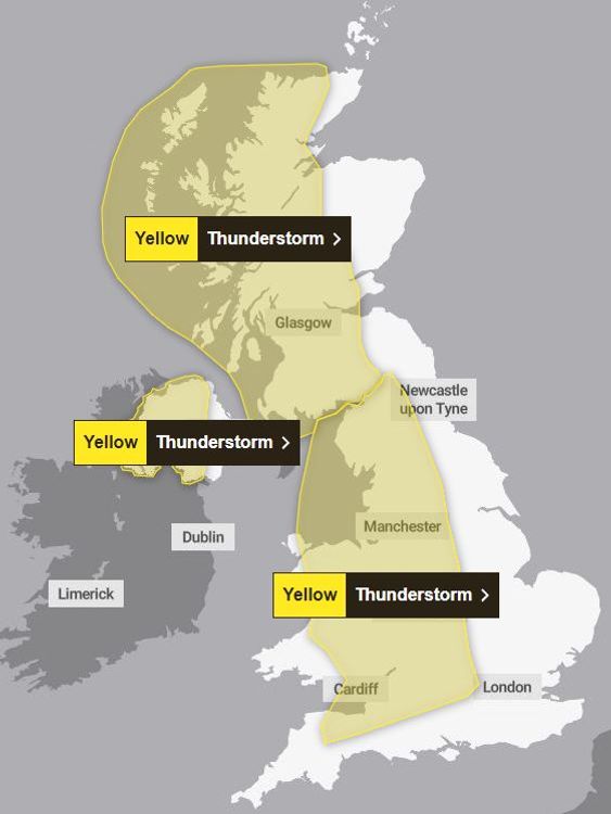
Thunderstorms are set to strike across large parts of the UK this afternoon - with a warning that flooding in some places could cause "danger to life".
The Met Office has issued a number of yellow weather alerts across the country, which look set to bring Britain's warm spell to an end.
From midday, western and central Northern Ireland will be the first to be hit, with Derry, Omagh, Enniskillen, Newry among the places warned that the anticipated heavy showers and thunderstorms could lead to difficult driving conditions, power cuts and flooding.
From 1pm, thunderstorms will sweep in across parts of Wales and western and central England.
Check the weather forecast in your area
The Met Office has warned: "Flooding of homes and businesses could happen quickly, with damage to some buildings from floodwater, lightning strikes, hail or strong winds.
"Fast flowing or deep floodwater is possible, causing a danger to life."
From 2pm, the storms will hit Scotland. The yellow weather alert stretches from southern Scotland up to the Central Belt as well as the Highlands and Islands.
The Met Office has warned Scots: "There is a small chance of fast flowing or deep floodwater causing danger to life."
The heavy showers and thunderstorms in Northern Ireland are expected to come to an end at around 7pm, and at 11pm in England and Wales.
The bad weather is expected to continue in Scotland until 3am on Monday.
Keep up with all the latest news from the UK and around the world by following Sky News
Tap hereThe thunderstorms could bring the UK's warm spell to a dramatic end - after Saturday was confirmed as the hottest day of the year so far.
Temperatures are forecast to hit 25C (77F) again on Sunday in parts of southern and central England, with humid conditions making it another springtime scorcher.
For England, Herstmonceux West End in East Sussex saw the highest temperature at 25.9C, while Cassley in the Scottish Highlands hit 25.7C.
Wales also saw 25.1C in Gogerddan, and Northern Ireland recorded 23.8C in Magilligan.
Read more from Sky News:
Global temperature streak continues with record hot April
London must adapt to 'new reality' as number of days over 30C rises
Stay safe in thunder and lightning
Before the thunderstorm:
• Lightning can cause power surges, so unplug any non-essential appliances if not already using a surge protector.
• Seek shelter if possible. When you hear thunder you are already within range of where the next ground flash may occur. Lightning can strike as far as 10 miles away from the centre of a storm.
During the thunderstorm:
• Telephone lines can conduct electricity so try to avoid using the landline, unless in an emergency.
• If outside, avoid water and find a low-lying open place that is a safe distance from trees, poles or metal objects.
• Be aware of metal objects that can conduct or attract lightning, including golf clubs, golf buggies, fishing rods, umbrellas, motorbikes, bicycles, wheelchairs, mobility scooters, pushchairs, wire fencing and rails. If you are in a tent, try to stay away from the metal poles.
• If you find yourself in an exposed location, it may be advisable to squat close to the ground with your hands on your knees and your head tucked between them. Try to touch as little of the ground with your body as possible. Do not lie down on the ground.
•If you feel your hair stand on end, drop to the above position immediately.
After the thunderstorm:
• Avoid downed power lines or broken cables.
•If someone is struck by lightning, they often suffer severe burns. The strike also affects the heart, so check if they have a pulse.
Driving in a thunderstorm:
• If you are caught out in thunder and lightning, it is advised that you wind up the windows and stay inside your car. In the vast majority of cars with a metal roof and frame, the frame will act as a conductive Faraday cage, passing the current around the passengers inside and on to the ground.
• Soft-top convertibles, with their fabric roofs, are the most at risk and could catch fire if struck by lightning.
• Be aware that current can travel through other parts of many modern cars, including GPS and radio systems. Cars with metal interior handles, foot pedals and steering wheels can also carry current.
• Cars can be damaged both internally and externally by lightning strikes.
• Thunderstorms can also bring a risk of sudden gusty winds. Those most at risk would include cyclists, motorcyclists and high-sided vehicles.
• Remember to give vulnerable road users including cyclists, motorcyclists and pedestrians more room than usual.
• Keep your speed down. Lowering your speed will lower the distance you travel when buffeted around by the wind.
• Hailstorms can be extremely dangerous to drive in - reducing your ability to see and be seen, as well as causing damage to your vehicle. If hail is severe, stop and pull over to a safe place and remain inside the vehicle.
Disclaimer: The copyright of this article belongs to the original author. Reposting this article is solely for the purpose of information dissemination and does not constitute any investment advice. If there is any infringement, please contact us immediately. We will make corrections or deletions as necessary. Thank you.