Met Office thunderstorm warnings will cover much of the UK later today.
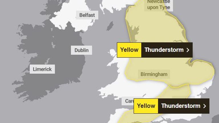
One existing alert has been extended to cover most of the north of England, while another was issued on Sunday morning for large swathes of central, southern and southwestern England.
The southern warning says heavy showers and thunderstorms may cause some disruption in places. It will be in place from 10am to 7pm on Sunday, covering parts of London, Oxford, Bath and stretching as far to the southwest as Exeter.
The larger warning - for storms and heavy showers - comes into force at 12pm and lasts until 8pm. It now stretches as far north as Carlisle and Newcastle, and covers areas like Birmingham and Cambridge further south.
What will the weather be like on Bank Holiday Monday?
Sky News weather producer Joanna Robinson said earlier this weekend: "Bank Holiday Monday will bring further showers, some thundery, but western parts will turn drier later on."
She had cautioned on Saturday that new weather warnings could be announced at short notice and has been proven right this morning.
Keep up with all the latest news from the UK and around the world by following Sky News
Tap hereThis breaking news story is being updated and more details will be published shortly.
Please refresh the page for the fullest version.
You can receive breaking news alerts on a smartphone or tablet via the Sky News app. You can also follow @SkyNews on X or subscribe to our YouTube channel to keep up with the latest news.
Disclaimer: The copyright of this article belongs to the original author. Reposting this article is solely for the purpose of information dissemination and does not constitute any investment advice. If there is any infringement, please contact us immediately. We will make corrections or deletions as necessary. Thank you.